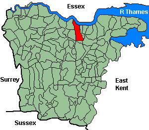
Northfleet
OS Grid Reference: TQ6274
The 1841 population was 3,621
The 1841 population was 3,621
Administrative Units
Northfleet fell within the Hundred of Toltingtrough. Its 19th century Registration District & Poor Law Union was North Aylesford 1835-84, Strood 1884-1930.
Probate Jurisdiction was Shoreham -1845, Rochester 1846-57.
Northfleet included the hamlets of Rosherville and Perry Street.
See NWKFHS publications West Kent Sources and School Records for further information.
Church and Chapels (pre 1910)
Northfleet, St Botolph
Church of England - Ancient Parish Church
Original Registers
These date from 1539.
Images published by NWKFHS (CD-Rom Ref OR6-9). See Parish Register Publications.
Original Registers
These date from 1539.
Images published by NWKFHS (CD-Rom Ref OR6-9). See Parish Register Publications.
St Botolph - Apr 1998

Perry Street, All Saints
Church built 1868-70; parish created 1871 from Northfleet St Botolph & Rosherville.
Original Registers
These date from 1871.
Images published by NWKFHS (CD-Rom Ref. OR31-32). See Parish Register Publications.
Original Registers
These date from 1871.
Images published by NWKFHS (CD-Rom Ref. OR31-32). See Parish Register Publications.
All Saints - Oct 2014

Church of England cont.
- Rosherville St Mark: Church built 1853, demolished 1976; parish created 1853 from Northfleet St Botolph. Original registers from 1853
Parish Register images published by NWKFHS (CD-Rom Ref. OR33). See Parish Register Publications.
Roman Catholic: Northfleet, Our Lady of the Assumption, The Hill
Church built 1914, superseding 'Our Immaculate Mother & St Joseph', Rose St. (built 1867).
Original Registers
These date from 1866.
Original Registers
These date from 1866.
Our Lady of the Assumption - Oct 2014

Congregational: Northfleet, Dover Rd
Church built 1950, now Northfleet Congregational Church
Oct 2014

Wesleyan/Methodist
- Wesleyan: Portland Rd. (1885). No information on registers.
- Methodist: Wood St. (1875).